
1. PURPOSE
According to the results of the meeting on 5th March 2018 with the Ministry of Housing, MEW, and PAHW, considering the efficiency of the land use plan and the rationality of the development conditions in the project area, it is necessary to abolish all scattered MEW pumping wells in the project area except for some monitoring wells. Therefore, the purpose of this study is to examine the appropriate method of relocation according to the abolition.
2. LIMITS OF THE STUDY
As the evaluation study described in this report has been conducted based on the SSAC Master Plan established on 7th March, the proposed locations and alignment of the pipeline could be changed depending on future updates to the Master Plan.
Additionally, this study has evaluated alternative routes for the pipeline only within the SSAC Project Site. And the evaluation of methods to close the existing well pumps and to prevent groundwater contamination will be replaced with the report written by Daltares, as the engineering firm is carrying out related tasks for the Project.
2.1 REFERENCE
- Master plan established on 7th March 2018
- Groundwater assessment for “Master plan and detailed design for South Saad Al Abdullah New City,” Phase 1: The impact of constructing a new city (SSAC) on the groundwater field, Deltares, 2017
- Groundwater assessment for “Master plan and detailed design for South Saad Al Abdullah New City,” Phase 1: Input to the environmental assessment study
- Groundwater assessment for “Master plan and detailed design for South Saad Al Abdullah New City,” Phase 1: Hydrologic analysis report
3. BACKGROUND
3.1 LOCATION OF THE PROJECT
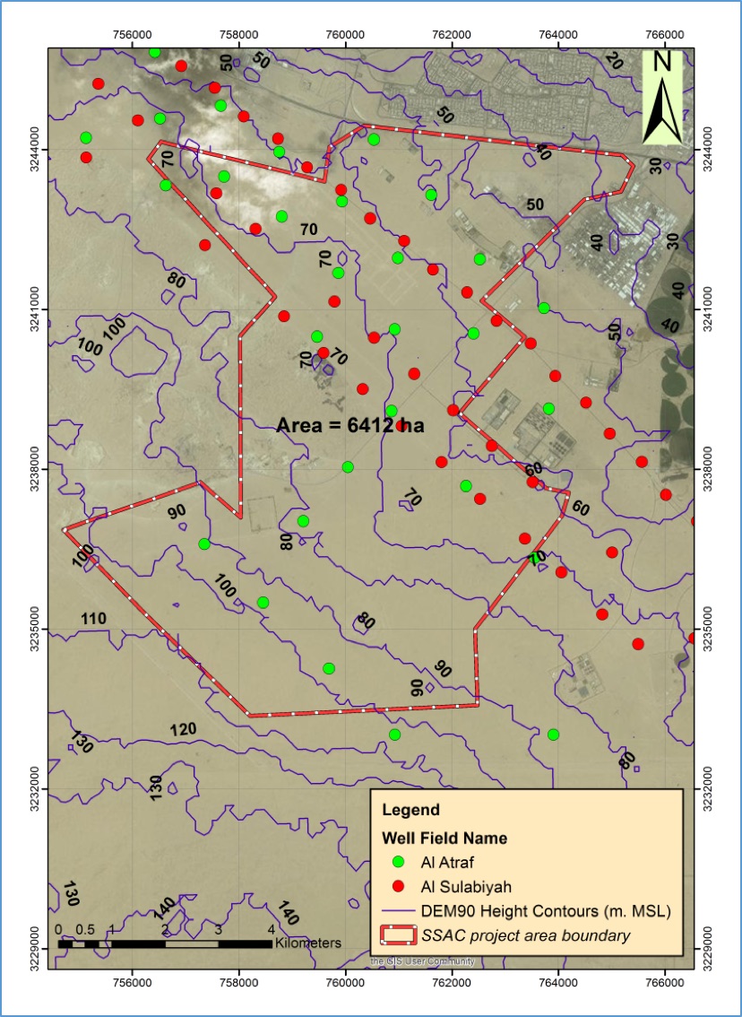
The location of the SSAC New City area is shown in Figure below, situated at 20 to 30 km west of the center of Kuwait City. In the present situation, the area consists of a gently undulating desert plain.

3.2 THE EXISTING CONDITION
The terrain heights in the project area, derived from DEM90 data (Digital Elevation Models from NASA, USA), vary from 100 m in the south to around 50 m in the north. The area consists mostly of barren gently undulating sandy flats locally with desert pavements, which become hilly in the southern parts where Aeolian dunes can be found. The area is littered with waste, like old tires, domestic waste, industrial solid waste, building debris, etc.
Groundwater abstractions well from two well fields are located within the SSAC project area: the Al-Atraf field and the Al-Sulaibiyah field (Figure 4.2). The Al-Sulaibiyah field is the oldest and the largest groundwater well field in Kuwait producing brackish groundwater from the limestone and dolomite Dammam formation aquifer. This field has 122 wells, of which 21 are located within the SSAC area, and 23 wells are located in the 4 km buffer zone around the SSAC are. These wells have a depth ranging between 222 and 382 meters and were drilled between 1963 and 1968. The brackish groundwater is mainly used for irrigation and domestic purposes. For domestic used it mixed with desalinated sea water to make it potable, in a ratio of 10% groundwater and 90% desalinated sea water.
The Al-Atraf field produces groundwater from the sandy and gravelly Kuwait Group aquifer, which is above the Dammam formation. This field has 83 wells, of which 18 are located within the SSAC area, and 17 wells are located in the 4 km buffer zone around the SSAC area. These wells have a depth ranging between 184 and 199 meters and were drilled between 1987 and 1990. The Al-Atraf well field produces irrigation water and drinking water after blending with desalinated.
The pumping wells situation within the present SSAC area is shown in Figure below.
According to the results of the meeting with Ministry of Housing, PAHW, MEW, LH, SUNJIN, and Deltares on 5th March 2018, all pumping wells within the project area was decided to be removed.
4. PIPELINE RELOCATION PLAN
4.1 EXISTING PIPELINES ON THE PROJECT SITE
As shown in Figure 4.1 below, there are four groups of pipelines that connect to the pumping wells of the MEW existing in the SSAC Project Site.
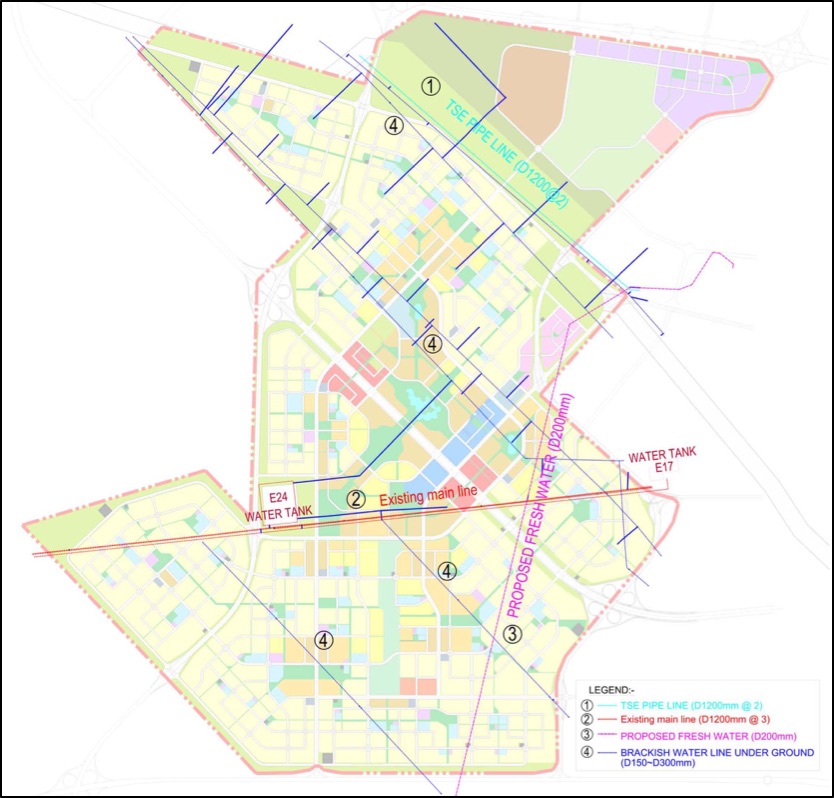
① TSE Pipelines on the North Side
This group of TSE pipelines, overseen not by the MEW but by the MPW, convey treated sewage effluent from the DMC east of the site to the Al-Abdali area for agricultural water use.
As a result of the MEW’s approval of the proposal to close the ministry’s pumping wells existing in the SSAC Project Site, it has become inevitable to propose alternative routes for these TSE pipelines, as part of the plan for relocating the pipelines existing in the Project Site.
Consisting of two lines of pipes with a diameter of 1200mm, this pipeline group is driven by pressure forces to convey groundwater. The types of the pipes are GRP(HS/71), D.I(HS/59). And the depth of soil cover above the pipes is -2.00m when measured from the ground elevation.
In a formal letter of July 10th 2017, the MPW stated to the KTCB that the relocation of these existing pipelines was not allowable and thus the planning consultant should plan corridors with a width of 10m around the pipelines as buffer zones.
② Irrigation Water Pipelines (Existing Main Line) on the South Side, Near Water Tanks
This group of irrigation water pipelines consists of two lines of pipes with a diameter of 1200mm coming from the west, outside the Project Site, to Water Tank E24 (New Sulabiya, V=55 million gal / 250,000㎥), and three lines of pipes with a diameter of 1200mm connecting Water Tank E24 to Water Tank E17 (Sulabiya, V1=35 million gal / 159,000㎥ & V2=30 million gal / 136,300㎥, a total of 65 million gal / 295,300㎥) east of the Project Site.
The other remaining pipelines belonging to this group are the transmission pipeline connected to the Doha East & West Plants (a desalination plant) north of the Project Site, and the one finally leading to the Blending Plant northeast of the Project Site.
These pipelines are controlled by gravity to convey water. They are made up of steel pipes and ductile iron(D.I.) pipes. And the depth of soil cover above the pipes ranges from -1.30m to -3.00m when measured from the ground elevation.
③ TSE Pipelines (to KISR) Running from North to South
Number ① pipelines overseen by the MPW as other TSE pipelines, this pipeline group, with a diameter of 200mm, runs from the DMC east of the Project Site to Kuwait Institute for Scientific Research(a research complex) south of the Project Site.
These pipelines are driven by gravity to convey water. They are assumed to be made up of D.I. pipes. And the depth of soil cover above the pipes ranges from -2.00m to -3.00m (to be expected) when measured from the ground elevation.
④ Others – Gathering Pipelines from Wells Existing in the Project Site
Within the SSAC Site, there are other pipelines that connect to Water Tank E24 (New Sulabiya) or existing main line (Number ② line). In addition, there are several pipelines that run across the site.
These pipelines are driven by pressure forces and gravity to convey water. They are assumed to be made up of D.I. pipes. And the depth of soil cover above the pipes ranges from -1.50m to -3.00m (to be expected) when measured from the ground elevation.
4.2 PIPELINE RELOCATION PLAN
The plan to relocate existing pipelines have been established taking into account all the necessary considerations including the working SSAC Master Plan, the Client’s requests, and the plan to accommodate utility lines below the ROW. The outcomes are shown in Figure below.

① Alternative routes for the TSE pipelines on the north side
As a result of the Master Plan drawing up a sufficient scale of green spaces on the areas of these pipelines, the need to relocate them has been eliminated.
② Alternative routes for the irrigation water pipelines(main lines) on the south side, near water tanks
These pipelines can be relocated below green spaces or roads(sidewalks) in the SSAC Master Plan, minimizing the loss of flow rates and velocity while keep being driven by gravity.
Sufficient space can be secured in the Master Plan to accommodate the pipelines that cross the 6.5 Ring Road and run into NCU plots, which will allow for the connection between them and the pipelines outside the Project Site.
③ TSE pipelines (to KISR) running from north to south
To minimize loss of flow rates and velocity based on the characteristics of pressure forces, it is planned to relocate these pipelines in underground space below green spaces secured in the Master Plan.
④ Other pipelines (gathering pipelines from existing wells)
Underground space below green spaces and sidewalks will be secured in the Master Plan to relocate these pipelines. At the same time, the interconnections among them will be mapped out in consideration of safety and easy maintenance.
The above plan could be changed depending on future updates to the SSAC Master Plan and additional request from relevant Kuwaiti ministries and authorities.
5. MONITORING PLAN
As a follow-up to the Kuwaiti Ministries’ approval of the closure of the existing pumping wells in the SSAC Project Site, we engineering consultants will establish the plan to select some out of them to maintain and use as monitoring wells in conjunction with the plan to replace the existing ones.
The selection of monitoring wells out of the existing pumping wells will be based on the following criteria:
- Whether they give access to different aquifers;
- Whether they are located on the areas in need of the monitoring of groundwater quality; and
- Other important considerations
5.1 REASONING BEHIND THE SELECTION CRITERIA
The following paragraphs explain the reasoning behind the decision to set the selection criteria mentioned above.
Access to different aquifers
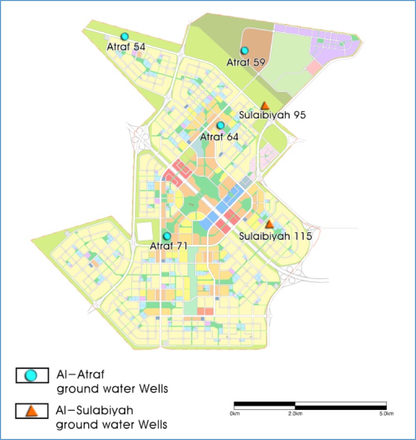
As shown in the “Hydrologic Analysis Report (Kloosterman and Van der Grift, Deltares, 2017)”, the aquifers tapped in the SSAC Project Site can be divided by two groundwater-bearing rock formations: the upper Kuwait Group and the lower Dammam Formation. Therefore, monitoring wells have to offer access to the two different aquifers.
Table 5.1 Pumping Wells Selected by Aquifer
| Monitoring Purpose | Groundwater-bearing rock formation | Well No. | TDS | No3- | CI- | Total Depth (m) | Water level (m) |
|---|---|---|---|---|---|---|---|
| To keep watch on water quality deterioration | Kuwait Group (Atraf) | 64 | 5,136 | 109.0 | 1,923 | 195.1 | 51 |
| Dammam Formation (Sulaibiyah) | 95 | 3,812 | 0.9 | 728 | 332.2 | 62 |
Groundwater quality
To keep under observation any change in groundwater quality, monitoring wells have to be located on two different kinds of locations, which are determined by the findings of the “Hydrologic Analysis Report” (Kloosterman et al., 2017): the one where the level of groundwater contamination is so high that the monitoring of any further degradation is mandatory; the other where groundwater quality is good enough to be used for landscape irrigation.
Table 5.2 Pumping Well Selected by Groundwater Quality
| Monitoring Purpose | Groundwater-bearing rock formation | Well No. | TDS | No3- | CI- | Total Depth (m) | Water level (m) |
|---|---|---|---|---|---|---|---|
| To determine the baseline water quality | Kuwait Group (Atraf) | 54 | 3,618 | 44 | 999 | 198.1 | 51 |
| Dammam Formation (Sulaibiyah) | 115 | 3,621 | 2.6 | 660 | 274.3 | 56 |
Other important considerations
Other main considerations to take into account in the selection process are the areas where the monitoring of salinity in groundwater is required because of the high possibility of seawater intrusion and the areas on the southern edge of the Project Site where groundwater levels are low in relation to other areas due to reckless groundwater abstractions in Saudi Arabia.
Table 5.3 Additional Selected Pumping Wells
| Monitoring Purpose | Groundwater-bearing rock formation | Well No. | TDS | No3- | CI- | Total Depth (m) | Water level (m) |
|---|---|---|---|---|---|---|---|
| To check ewawater intrusion | Kuwait Group (Atraf) | 59 | 4,526 | 37.1 | 1,674 | 173.7 | 36 |
| To check already low water levels on the southern edge | Kuwait Group (Atraf) | 71 | 5,403 | 153.6 | 1,908 | 167.6 | 54 |
5.2 LOCATION OF SELECTED MONITORING WELLS
The results of the process of selecting monitoring wells, based on the criteria above and the SSAC Master Plan, are shown on the map below.
Figure 5.2 Locations of Selected Monitoring Wells
CONCLUSION
-
Groundwater abstractions well from two well fields are located within the SSAC project area: the Al-Atraf field and the Al-Sulaibiyah field.
-
The Al-Sulaibiyah field is dolomite Dammam formation aquifer. This field has 21 wells within the SSAC area.
-
The Al-Atraf field produces groundwater from the sandy and gravelly Kuwait Group aquifer, which is above the Dammam formation. This field has 18 wells within the SSAC area.
-
In addition, because MEW pumping wells mentioned above, pipelines connecting the wells, and agricultural water supply pipeline are buried in the project area, all of the conditions related to the pipelines should be considered in the planning stage.
-
In particular, it is necessary to confirm whether or not the 1200mm pipe supplied to the Kuwait Institute Scientific Research was constructed through consultation with MEW.
-
Considering such a comprehensive situation, we have established a reconnection plan to relocate each channel, but it is necessary to review the sustainability after the land use plan is finalized.
-
Regarding the selection of monitoring wells, a total of six monitoring wells have been selected: four to monitor two aquifers in different rock formations, to determine the baseline groundwater quality, and to check a worsening in groundwater contamination; two to keep watch on seawater intrusion and to observe a decrease in already lower groundwater levels on the southern edge of the Project Site.